Earth Systems and Resources
Unit Four
Earth's systems—such as the lithosphere, atmosphere, hydrosphere, and biosphere—are interconnected, and understanding their interactions is key to addressing environmental challenges like climate change, resource management, and ecosystem preservation.

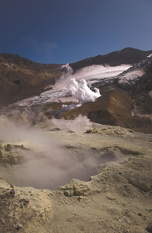
Plate Tectonics and Geological Processes
Theory of Plate Tectonics: Earth's lithosphere is divided into tectonic plates that move due to convection currents in the asthenosphere.
Types of Plate Boundaries:
-
Divergent Boundaries: Plates move away from each other, allowing magma to rise and create new crust.
-
Example: Mid-Atlantic Ridge- An underwater mountain range formed by the divergence of the Eurasian and North American plates.
-
Geological Processes:
-
Weathering: The breakdown of rocks through physical (e.g., frost wedging), chemical (e.g., oxidation), and biological processes.
-
Erosion: The movement of weathered materials by wind, water, ice, or biological activity. Rivers often transport eroded sediments to deltas.
-
Deposition: The laying down of sediments in new locations, contributing to the formation of features like river deltas and sand dunes.
-
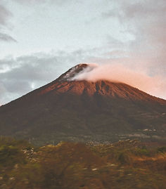
Volcanic Activity: Occurs mostly at convergent and divergent boundaries, forming volcanoes. Examples:
-
Shield Volcanoes: Gentle slopes, found at hotspots (e.g., Hawaiian Islands).
-
Composite Volcanoes: Steeper slopes, common at subduction zones (e.g., Mount St. Helens).
-
-
Earthquakes: Release of energy from tectonic movements, creating seismic waves measured by the Richter scale and modified Mercalli scale.

-
Convergent Boundaries: Plates move towards each other, often causing one plate to subduct beneath another, leading to volcanic activity or mountain formation.
-
Oceanic-Continental Convergence: Oceanic crust subducts beneath continental crust, forming volcanic mountain ranges (e.g., Andes Mountains).
-
Continental-Continental Convergence: Two continental plates collide, forming large mountain ranges (e.g., the Himalayas).
-
-
Transform Boundaries: Plates slide horizontally past each other, leading to earthquakes.
-
Example: San Andreas Fault in California
-
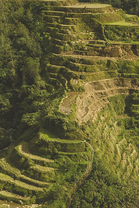
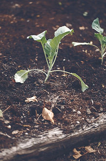
Soil Formation and Erosion
Soil Formation
Soil formation begins with the weathering of parent material, the base material from which soil develops. Weathering processes break down rocks into smaller particles, and over time, organic matter from plants and organisms contributes to soil development.
Steps in soil formation:
-
Weathering: Physical (freeze-thaw cycles, abrasion) and chemical (acid rain, oxidation) processes break rocks into smaller particles.
-
Deposition: Wind, water, and glaciers transport materials from other areas, enriching the soil.
-
Vegetation Growth: Moss and small plants grow in the initial soil, contributing organic matter and nutrients.
-
Soil Horizons: Over time, distinct layers form.

Soil Horizons
-
O Horizon (Organic Layer): Composed of surface litter like leaves and decomposing organic matter.
-
A Horizon (Topsoil): A mix of minerals and organic matter, rich in nutrients, and ideal for plant growth.
-
E Horizon (Eluviated Layer): A zone of leaching where nutrients and minerals are washed downward.
-
B Horizon (Subsoil): Accumulated minerals like iron and clay, making it denser.
-
C Horizon (Parent Material): Weathered rock fragments, the precursor to soil.
-
Bedrock: The unweathered rock beneath all soil layers.

Soil Erosion
Soil erosion occurs when vegetation is insufficient to anchor soil, allowing wind and water to wash it away. This process:
-
Depletes soil nutrients, as seen during the Dust Bowl.
-
Reduces water filtration, leading to polluted water.


Soil Composition and Properties

Soil Particle Properties
Soil's porosity, permeability, and fertility are influenced by particle size:
-
Porosity: Larger particles create bigger pores, increasing aeration.
-
Permeability: Larger particles enable better water and nutrient flow.
-
Fertility: Affected by organic matter and nutrient content, essential for vegetation.
Water-Holding Capacity
Soil's ability to retain water depends on:
-
Particle size: Smaller particles (e.g., clay) retain more water, while larger particles (e.g., sand) allow water to drain quickly.
-
Organic matter: Increases water retention as it absorbs and holds moisture.
-
Ideal Soil (Loam): A balanced mix of sand, silt, and clay, with excellent water retention and drainage properties.

Soil Properties
-
Chemical: Includes pH and cation exchange capacity (CEC). Higher CEC allows soil to retain nutrients and maintain stability.
-
Physical: Features like aeration, compaction, and permeability determine soil quality.
-
Biological: Microorganisms, fungi, and plants influence nutrient cycling and soil health.


Atmosphere and Climate Systems
Atmospheric Composition: Mostly nitrogen (78%) and oxygen (21%), with trace gases including argon, CO₂, methane, and water vapor.

1. Troposphere
-
Altitude: 0–12 km
-
Features: Closest to Earth; where weather occurs. Temperature decreases with altitude.
2. Stratosphere
-
Altitude: 12–50 km
-
Features: Contains the ozone layer, absorbs UV radiation. Temperature increases with altitude.
3. Mesosphere
-
Altitude: 50–85 km
-
Features: Burns up meteors, making it the coldest layer. Temperature decreases with altitude.
4. Thermosphere
-
Altitude: 85–600 km
-
Features: Very high temperatures due to solar radiation absorption; feels cold due to low air density.
5. Exosphere
-
Altitude: 600 km and up
-
Features: Outermost layer; where particles escape into space. Temperature varies widely.
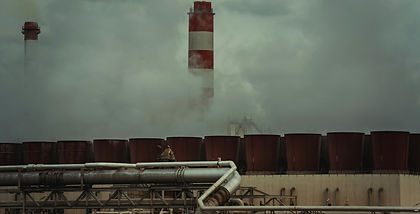
Greenhouse Gases: Key contributors include:
-
CO₂: Released from fossil fuels and deforestation.
-
Methane (CH₄): Emitted from livestock, agriculture, and landfills.
-
Nitrous Oxide (N₂O): Comes from agriculture and fossil fuel combustion.
-
These gases trap heat in the atmosphere, causing the greenhouse effect and contributing to global warming.
Global Wind Patterns
Uneven Solar Heating
-
The equator receives direct sunlight, warming the air and causing it to rise.
-
At the poles, sunlight is indirect, resulting in cooler, denser air that sinks.
Convection Cells
Global air circulation operates in three main convection cells in each hemisphere:
-
Hadley Cells (0°–30° Latitude)
-
Warm air rises near the equator, cools as it moves poleward, and sinks at 30° latitude.
-
Creates tropical rainforests near the equator and deserts near 30°.
-
-
Ferrel Cells (30°–60° Latitude)
-
Mixes warm air from the tropics and cool air from the poles.
-
Causes variable weather in mid-latitudes.
-
-
Polar Cells (60°–90° Latitude)
-
Cold air sinks at the poles and flows toward 60°, creating dry, frigid polar climates.
-
Wind Patterns
-
Trade Winds: Blow westward between 0°–30° latitude due to the Coriolis effect.
-
Westerlies: Eastward winds in the mid-latitudes (30°–60°).
-
Polar Easterlies: Westward winds near the poles (60°–90°).

Coriolis Effect
-
Due to Earth’s rotation, moving air curves:
-
Northern Hemisphere: Deflected to the right.
-
Southern Hemisphere: Deflected to the left.
-

Jet Streams
-
Fast-moving currents of air located near the boundaries of convection cells.
-
Polar Jet Stream: Found between Polar and Ferrel cells.
-
Subtropical Jet Stream: Located between Ferrel and Hadley cells.
-

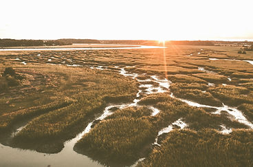
Watersheds


A watershed is an area of land where all precipitation and runoff drain into a common discharge point, such as a river, lake, or ocean.
Importance of Watersheds
-
Control water flow into ecosystems.
-
Influence flood risks and erosion.
-
Affect water quality and supply for nearby communities.
Key Characteristics
-
Size: Determines the amount of water collected.
-
Slope: Steeper slopes increase runoff speed but can cause erosion.
-
Soil Type:
-
Sandy soil: High infiltration, less runoff.
-
Clay soil: Low infiltration, more runoff.
-
-
Vegetation:
-
Plants reduce runoff, prevent erosion, and improve water quality by filtering pollutants.
-
Solar Radiation Distribution
-
Strongest at the equator, where sunlight is most direct.
-
Weakens toward the poles due to the Sun’s angle.

Earth’s Tilt
-
Earth is tilted at an angle of 23.5°, causing the intensity of sunlight to vary throughout the year.
-
As Earth orbits the Sun, different hemispheres receive more direct sunlight, creating seasons.
Solar Radiation & Earth's Seasons
Seasonal Changes
-
Summer (in the hemisphere tilted toward the Sun):
-
Longer days, more direct sunlight.
-
-
Winter (in the hemisphere tilted away from the Sun):
-
Shorter days, indirect sunlight.
-
-
Equinoxes:
-
Occur in spring and fall when day and night are nearly equal.
-

Geography & Climate
Factors Influencing Climate
Solar Radiation:
-
The primary source of energy for Earth’s climate system.
-
Intensity varies with latitude and time of year.
Earth’s Orbit:
-
Changes in Earth’s orbit (Milankovitch cycles) affect the distribution of solar energy over thousands of years, influencing ice ages.
Greenhouse Gases:
-
Carbon dioxide (CO₂), methane (CH₄), and water vapor trap heat, warming the planet.
Volcanic Activity:
-
Eruptions release particles that block sunlight, temporarily cooling the climate.
Ocean Currents:
-
Redistribute heat by moving warm and cold water across the globe.
-
Examples: The Gulf Stream warms Europe; cold currents cool coastal deserts.

Topography:
-
Mountains: Create the rain shadow effect.
-
Windward side: Warm, moist air rises and cools, causing precipitation.
-
Leeward side: Dry air descends, creating arid conditions.
-

El Niño & La Niña
El Niño-Southern Oscillation (ENSO)
ENSO describes natural variations in the Pacific Ocean that influence global weather. It occurs in two main phases:
-
El Niño:
-
Trade winds weaken, reducing upwelling of cold water in the eastern Pacific.
-
Causes warm ocean water to spread eastward, altering global weather:
-
Warmer winters in North America.
-
Increased rainfall in South America.
-
Droughts in Australia and Southeast Asia.
-
-
-
La Niña:
-
Stronger trade winds enhance upwelling, bringing cold water to the surface.
-
Effects:
-
Colder winters in North America.
-
Increased rainfall in Australia and Southeast Asia.
-
-
Impacts
-
Affects fishing industries (due to changes in nutrient availability).
-
Alters agricultural productivity worldwide.

